
We have been testing the JAVAD equipment lately. The receiver we used is the Triumph-LS which has the receiver and data
collector incorporated into one unit with a battery life of 30 hours. It utilizes all the current satellite systems, is
designed to incorporate additional systems when they become available. It comes with a lifetime offer of software
upgrades. The main reason we offered to test it was to see if it would produce better results under canopy than our
present equipment and IT DID. It utilizes over 800 channels and 6 engines and an auto-verification system that will
guarantee the results if you follow the guidelines. If fact, if you can prove you got a bad fix, they will pay you $10,000.
Cameras are incorporated in the unit. The software programs have lots of useful tools and their customer service was
very good. They are very open to suggestions for improvements or changes to the software and very efficient at incorporating
beneficial recommendations. We are considering ordering units for all our surveyors if affordable.
One important thing we learned while testing the equipment: If you are using a VRS signal when you are working in areas
with lots of tree cover and getting lots of multipath signals when trying to get fixed RTK results, you will get better
results if you set up your base nearby and use the base instead of VRS (that applies to all brands). And with the JAVAD
equipment you may get additional satellites.
The JAVAD equipment is also much-much less expensive that other brands, has tilt compensation, has a collapsible rover
rod, has a touch screen with an alternate touch pen in case you don’t want to use your fingers and the entire unit is
much more compact so it takes up much less space in your vehicle.
I have always dreamed of the "black box" that would give you accurate location coordinates no matter where you are.
The Javad equipment is the next step.
Gary Kratz
Regional Land Surveyor
US Fish and Wildlife Service
For a while I have been eagerly awaiting my equipment
trial and it has finally come. I realize that a lot of feedback
has already been received and lots of changes and modifications
have already been made before I have received
my trial equipment, which is great to see.
Here are some random thoughts, suggestions, and
notes after I have had a chance to use the equipment.
I am no stranger to GNSS equipment and this stuff
performs!It is very evident that this setup was designed
from the ground up. There is no imitation in the design and
there is no equal out there on the market that I know of in
terms of features, performance and price. Your team has
definitely thought “outside of the box” and that has made
all the difference!The small footprint of the equipment is
amazing. I would suggest to include/offer a custom pelican
case that can hold base, rover, radio, cables, etc. Being
compact is very attractive to me.
Hardware: I love the bluetooth radio!Not having a cable
from the base to the radio is great. I had my concerns
about the range of the 1W radio... until I tested it. With the
antenna mounted approximately 20 feet above the ground,
I was able to maintain a radio link 3 miles away in rolling hills here in
northeastern Ohio. That is pretty impressive compared to some of the other
systems that I have used. One suggestion is that I would love to see backlit
buttons. The downward facing flashlight is great and if the buttons were
illuminated, I might never come home at night!
Software: I really like the flexiblity of changing units
and coordinate systems on the fly. The page concept is
great. Having DPOS built into J-Field is amazing but I
think it needs a little refinement. I processed a base point
through DPOS and then through OPUS and the difference
in values was about 0.5’ horizontally and vertically. Matt
Johnson looked into this for me and some changes were
made, but it leaves me wondering. The effort made to be
able to do all of this right from the receiver is fantanstic
and when I presented this issue to him, he and the team
checked into the problem promptly and responded very
quickly. I have been very pleased with the turnaround time
and the idea that I can talk to real surveyors with my questions
and concerns is great. Well done here!
Joseph Paulin, P.S.

Without question, the Triumph-LS is the most
mind-blowing piece of technology that I have ever
held in my hands and being able to work with it is
the highlight of my 40-year career in land surveying.
Intertwined and commensurate with that highlight
has also been the incredible honor and privilege in
working with Javad Ashjaee, his amazing Moscowbased
team of scientists and engineers, as well as
some of the brightest surveyors in the United States,
all in the shaping of the Triumph-LS and its graphical
user interface, J-Field.
There are so many features of the Triumph-LS
worth highlighting, it's difficult to know where to start;
from the built-in frequency scanners for both UHF
interference and GNSS interference, the automated
shifting of project coordinates after the base file has
been submitted to DPOS (Javad's own version of
OPUS for .jps files) and its adjustment received –
all being done by J-Field, or to start by mentioning
Visual Stakeout using J-Field's unique and way cool
Guide feature. The ability to locate objects using
photogrammetric methods is another exciting tool
included in J-Field's extensive tool-set.
Being a person that has always gravitated to
understanding things visually, J-Field's approach
and graphical displays has aided my transition
from strictly being an L1 guy for more than a dozen
years; (6) ProMark2 Ashtech1 receivers, to finally
get with today's surveying using RTK. Of course,
the Triumph-LS's very competitive price point also
made this transition possible.
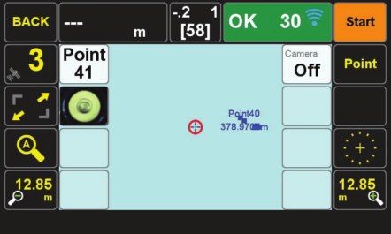 Shown here is just one
example of the visual
presentation of information
given the surveyor. It
includes being able to see
at a glance the image of
the rod bubble beneath the
instrument's second camera
and the textual display
of Triumph-LS's internal
pitch and roll values.
Shown here is just one
example of the visual
presentation of information
given the surveyor. It
includes being able to see
at a glance the image of
the rod bubble beneath the
instrument's second camera
and the textual display
of Triumph-LS's internal
pitch and roll values.
If I was limited to saying only one thing about the
Triumph-LS that has impressed me the most, I'd
have to say that it doesn't have anything to do with
technology whatsoever. It has to do with a GNSS
manufacturer that has so openly embraced the surveying
profession during the development of a specific
product, and most notably, professional land
surveyors in the United States. As a matter of policy,
Javad GNSS users are encouraged to suggest
improvements and new features to all Javad GNSS
products. And nowhere is that policy reflected more
clearly than in J-Field.
The Javad PLS Support Network is an other
reflection of Javad GNSS's commitment to supporting
the U.S. Professional Land Surveyor and their use of Javad equipment. Composed of a core
group of licensed professional land surveyors scattered
across the United States, the so-called 5PLS
members stand ready to assist by phone or email.
The best method of support is actually using the
website's support forum which serves not only as a portal
to quickly getting answers to questions from all of
the licensed land surveyors, Javad GNSS geodesists,
scientists, engineers and even Javad Ashjaee
himself, but also ever increasingly the support forum
serves as a reference source and suggestion box.
1 Ashtech was the first GNSS company that was founded by
Javad Ashjaee.
V. Kelly Bellis, PLS
Horizon Surveying Co., Inc.
Ellsworth, Maine 04605
kellybellis@gwi.net